Even as the rain stopped late Tuesday morning, a deluge and swollen rivers created “historic and catastrophic” flooding in Vermont, Gov. Phil Scott (R) said Tuesday, with officials warning that more rainfall is expected as early as Thursday, threatening another wave of flooding and damage.
Northeast storms dump over 2 months’ worth of rain on Vermont: Live weather updates
Vermont’s capital, Montpelier, closes downtown as river reaches historic levels. National Weather Service warns of more potential flash floods.
More than 100 people have been rescued by boat as authorities rushed to rescue those stranded in hard-hit and remote areas. Thousands have lost homes or businesses and “countless” roads have been washed out, authorities said. No deaths had been reported in the state, but officials said search-and-rescue would take at least several days.
Officials hoped to begin damage assessments by Tuesday evening or Wednesday morning.
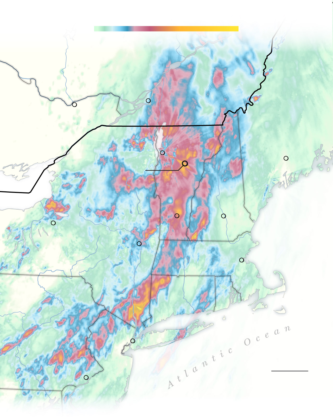
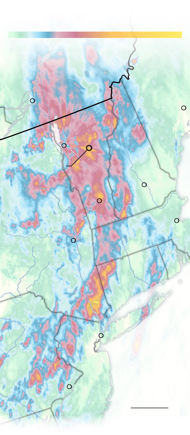
48-hour estimated rainfall
In inches as of 8 a.m., July 11
2
4
6
10
QUEBEC
MAINE
Montreal
CANADA
Ottawa
U.S.
ONTARIO
VER.
Augusta
Burlington
Montpelier
N.H.
Londonderry
Concord
Syracuse
Albany
NEW YORK
Boston
MASS.
CONN.
R.I.
PA.
New York
50 MILES
N.J.
Philadelphia
Source: NOAA
THE WASHINGTON POST

48-hour estimated rainfall
In inches as of 8 a.m., July 11
2
4
6
10
QUEBEC
MAINE
Montreal
Augusta
CANADA
VER.
Ottawa
U.S.
Burlington
ONT.
N.H.
Montpelier
Concord
NEW
YORK
Londonderry
Boston
MASS.
Albany
R.I.
Syracuse
CONN.
PA.
New York
Atlantic
Ocean
N.J.
50 MILES
Philadelphia
THE WASHINGTON POST
Source: NOAA
48-hour estimated rainfall
In inches as of 8 a.m., July 11
2
4
6
10
QUEBEC
MAINE
Montreal
Augusta
CANADA
VER.
U.S.
N.H.
Burlington
Montpelier
Concord
NEW
YORK
Londonderry
Boston
MASS.
Albany
R.I.
CONN.
PA.
New York
Atlantic
Ocean
N.J.
Philadelphia
50 MILES
THE WASHINGTON POST
Source: NOAA
Key updates
- Scott said Tuesday that flood levels in some areas had surpassed those recorded during Tropical Storm Irene in 2011, which killed at least three people in Vermont and severely crippled much of the state’s roadways.
- Authorities begged residents not to drive in flooded areas and asked them not to “self-deploy” as volunteers. The post-disaster recovery phase has not yet begun, officials said, as they continue attempts to find stranded and trapped people. “This is going to be a very long term search-and-rescue operation,” said Michael Cannon, program manager for the state’s urban search and rescue team. “I expect this to take at least several days if not longer.”
- Thirteen Vermont water rescue teams and five helicopters were being aided by out-of-state rescue crews and state troopers, with more personnel en route from additional states, officials said. With many areas still covered by water, it was too early to assess the full scope of the damage — or what it will take to recover.
- The National Weather Service continued to issue a litany of flash flood warnings Tuesday that extended across a swath of the state. Downpours, and possibly further flooding, could return to Vermont as soon as Thursday afternoon, NWS said.
Skip to end of carousel
End of carouselFloods and flash flooding can be dangerous and potentially fatal. They occur when excess water accumulates faster than the ground can absorb it, leading to runoff, like during extreme rainfall or snowmelt.
While flooding is generally an event that can last days or weeks, flash floods can occur rapidly, developing within hours of the cause, often during extreme weather events. Last year, five “1,000-year rain events” struck the country in five weeks.
If a flood watch is issued for your area, be aware and check weather reports. Flood warnings require immediate action because severe weather is imminent and flooding will probably occur.
If an evacuation is advised for your area, leave immediately. But don’t enter or drive through floodwater because it takes only a foot of fast-moving water to sweep vehicles away. Know the catchphrase: Turn around, don’t drown.
1/4
- President Biden, while in Vilnius, Lithuania for a NATO summit, declared an emergency in Vermont due to the flooding and ordered federal assistance to supplement state and local response efforts. Scott said this would allow more flexibility to deploy necessary resources.
Toll in Montpelier
- Vermont’s capital, Montpelier, closed its flooded downtown after storms dumped nine inches of rain — more than two months’ worth — on the state from late Sunday into early Tuesday, forcing residents and businesses to evacuate and the city to move its dispatch, police and fire operations because of flooding. On Tuesday afternoon, the city issued a boil-water notice for all residents relying on Montpelier’s water system. The city’s emergency order expired 3 p.m. Tuesday, but residents were still urged to avoid public travel.
- By Tuesday afternoon, Montpelier’s downtown remained underwater, but water levels were slowly receding, said William Fraser, the city manager. Officials hoped to begin damage assessments by Tuesday evening or Wednesday morning. The damage is likely extensive, and Montpelier may take months to recover. “It’s going to be a long, arduous process," he said.
- The Winooski River, which runs through Montpelier, reached 21.35 feet Tuesday morning. It hasn’t been that swollen since the Great Vermont Flood of 1927, when it reached a record 27 feet and killed 84 people, including the lieutenant governor. The river remained dangerously high Tuesday afternoon and continues to pose a threat to anyone near the floodwater, city officials said.
- Officials said that the threat of a breach at the nearby Wrightsville Dam has subsided. The breach would have been unprecedented, potentially sending more water into the Montpelier and threatening areas where evacuation routes have already been flooded. As of 4 p.m. Tuesday, the dam held at maximum capacity, city officials said. “We have monitored the water levels at the Wrightsville Dam for the last two hours and seen no significant changes,” the Montpelier Police Department said Tuesday afternoon. Minimal increases are expected, and officials will continue to monitor the dam through the night.
Impacted areas
- State emergency-response teams conducted swift-water rescues in the Londonderry, Weston, Ludlow, Berlin and Chelsea areas. More than a dozen shelters were opened overnight across the state to accommodate displaced residents. In Woodstock, residents were told to boil water Tuesday, as authorities worked on repairing the water system after a leak cut off service, the police department said.
- In Plymouth, a stream that parallels Route 100 caused the collapse of at least four bridges, according to witnesses, leaving families in homes uphill stranded. At the Hawk Mountain Resort, water poured down the mountainside. Natalya Bochkov, 55, watched a mudslide cause a road to flood Monday. “It’s muddy, it’s raging, it looks like white water,” she said.
- According to data from the First Street Foundation, a research group that quantifies climate risk, the number of properties at risk from flooding is growing far beyond what the Federal Emergency Management Agency considers to be at risk of 1-in-100-year floods. The foundation estimates there are five times as many.

